Layer Properties
You can view and edit layer properties in GeoExplorer.
Note
The properties of layers based on third party data, such as Google, cannot be viewed or edited.
To access the Layer Properties panel, click a layer in the Layers panel, then click Layer Properties  on the Layer panel toolbar. Alternatively, right-click the layer and click Layer Properties in the shortcut menu.
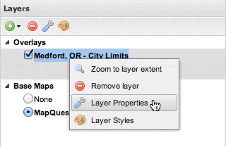
Layer Properties tool
There are three tabs in the Layer Properties panel:
| Name | Description |
|---|---|
| About | Displays layer metadata |
| Display | Options for customizing layer display |
| Available Styles | Option for choosing a layer style |
About tab
The About tab displays layer metadata and includes:
| Field | Description | Editable? |
|---|---|---|
| Title | Human-readable title of the layer | Yes |
| Name | Internal name for the layer | No |
| Description | Descriptive summary of the layer. Also known as the Abstract. | Yes |
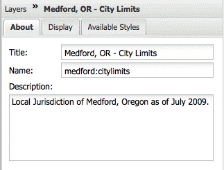
Layer metadata properties
Display tab
The Display tab provides options for customizing the display of layers in GeoExplorer.
| Field | Description |
|---|---|
| Opacity | Determines the level of transparency for the layer. Default is 100% opaque. You can adjust opacity by dragging the slider bar. |
| Format |
|
| Transparent | Sets transparency for a given layer (boolean value). Default is selected. If this check box is cleared, the layer displays like a Base Map, obscuring any layers drawn beneath it. See the Layer order section for more information on how layers are drawn. |
| Cache | Use cached version of layer (via the integrated GeoWebCache in GeoServer). Default is selected. Clear check box if you don’t want to use the cached version. |
| Info format |
|
| Limit with filters (optional) |
|
| Limit by scale (optional) |
|
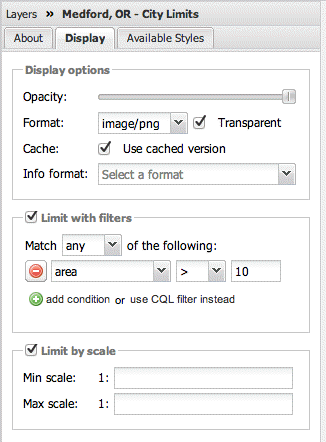
Layer display properties
Styles tab
The Styles tab provides access to the Styles editor. This editor allows you to view, add, edit, and delete styles and individual style rules for layers published by a WMS server adopting the SLD standard. Editing styles is only available for layers in the Overlays folder.
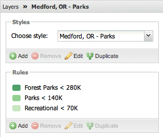
Layer style properties
Please refer to Layer Styles for more information on styling.
Note
Since editing and deleting styles requires authentication, you must be logged into GeoServer. If you are not connected to GeoServer, the Styles editor will be read-only.