WMS Decorations
WMS Decorations provide a framework for visually annotating images from WMS with absolute, rather than spatial, positioning. Examples of decorations include compasses, legends, and watermarks.
Configuration
To use decorations in a GetMap request, the administrator must first configure a decoration layout. These
layouts are stored in a subdirectory called layouts in the GeoServer Data Directory as XML files, one file per layout.
Each layout file must have the extension .xml. Once a layout foo.xml is defined, users can request it by
adding &format_options=layout:foo to the request parameters.
Layout files follow a very simple XML structure; a root node named layout containing any number of decoration elements. Each decoration element has several attributes:
| Attribute | Meaning |
type |
the type of decoration to use (see Decoration Types) |
affinity |
the region of the map image to which the decoration is anchored |
offset |
how far from the anchor point the decoration is drawn |
size |
the maximum size to render the decoration. Note that some decorations may dynamically resize themselves. |
Each decoration element may also contain an arbitrary number of option elements providing a parameter name and value:
<option name="foo" value="bar"/>
Option interpretation depends on the type of decoration in use.
Decoration Types
While GeoServer allows for decorations to be added via extension, there is a core set of decorations included in the default installation. These decorations include:
The image decoration (type="image") overlays a static image file onto the document. If height and width are
specified, the image will be scaled to fit, otherwise the image is displayed at full size.
| Option Name | Meaning |
url |
provides the URL or file path to the image to draw (relative to the GeoServer data directory) |
opacity |
a number from 0 to 100 indicating how opaque the image should be. |
The scaleratio decoration (type="scaleratio") overlays a text description of the map’s scale ratio onto the
document.
| Option Name | Meaning |
bgcolor |
the background color for the text. supports RGB or RGBA colors specified as hex values. |
fgcolor |
the color for the text and border. follows the color specification from bgcolor. |
The scaleline decoration (type="scaleline") overlays a graphic showing the scale of the map in world units.
| Option Name | Meaning |
bgcolor |
the background color, as used in scaleratio |
fgcolor |
the foreground color, as used in scaleratio |
fontsize |
the size of the font to use |
transparent |
if set to true, the background and border won’t be painted (false by default) |
measurement-system" |
can be set to “metric” to only show metric units, “imperial” to only show imperial units, or “both” to show both of them (default) |
The legend decoration (type="legend") overlays a graphic containing legends for the layers in the map.
The text decoration (type="text") overlays a parametric, single line text message on top of the map. The
parameter values can be fed via the the env request parameter, just like SLD enviroment parameters.
| Option Name | Meaning |
message |
the message to be displayed, as plain text or Freemarker template that can use the env map contents to expand variables |
font-family |
the name of the font used to display the message, e.g., Arial, defaults to Serif |
font-size |
the size of the font to use (can have decimals), defaults to 12 |
font-italic |
it true the font will be italic, defaults to false |
font-bold |
if true the font will be bold, defaults to false |
font-color |
the color of the message, in #RRGGBB or #RRGGBBAA format, defaults to black |
halo-radius |
the radius of a halo around the message, can have decimals, defaults to 0 |
halo-color |
the halo fill color, in #RRGGBB or #RRGGBBAA format, defaults to white |
Example
A layout configuration file might look like this:
<layout>
    <decoration type="image" affinity="bottom,right" offset="6,6" size="80,31">
        <option name="url" value="pbGS_80x31glow.png"/>
    </decoration>

    <decoration type="scaleline" affinity="bottom,left" offset="36,6"/>

    <decoration type="legend" affinity="top,left" offset="6,6" size="auto"/>
</layout>
Used against the states layer from the default GeoServer data, this layout produces an image like the following.
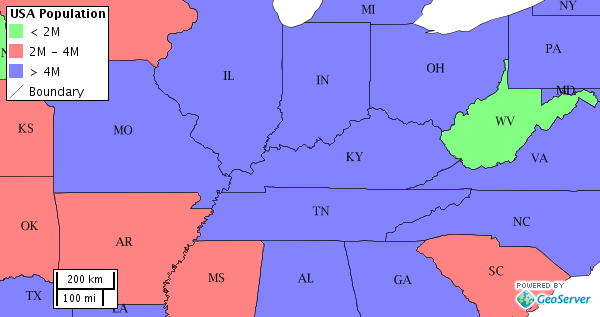
The default states layer, drawn with the decoration layout above.