How to add startup parameters for GeoServer
GeoServer allows global configuration settings to be provided as Java system properties for use during the startup process. Java system properties can be supplied on the command line using -D (and are of the form -Dproperty=value or -D property=value).
This section shows how to set the Java system properties used during startup.
Jetty
OpenGeo Suite for Windows and OS X both use the Jetty application server. Startup flags are all contained in a file called start.ini.
On Windows, this file is contained in jetty\start.ini inside the root of the installation directory. For example, C:\Program Files\Boundless\OpenGeo\jetty\start.ini.
To access the start.ini file on OS X, click Open Webapps from the GeoServer menu. The file is one level up in the directory tree.
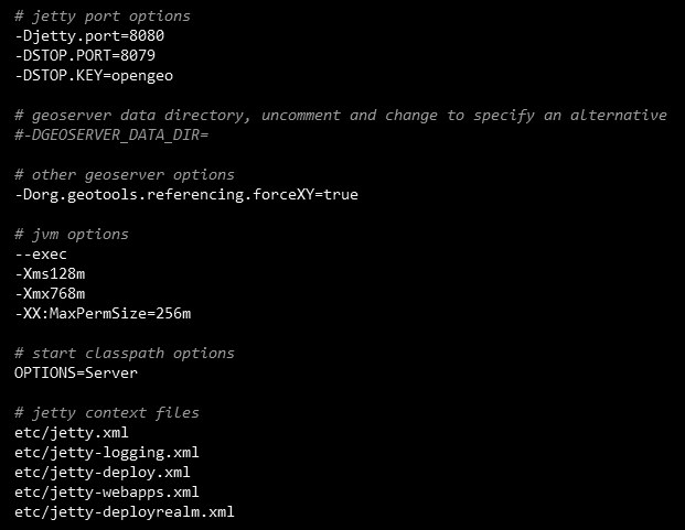
A sample start.ini file
This file contains a mix of JVM parameters (such as memory settings) and system properties. There is a section titled other geoserver options where startup options can go, but the specific order is not important. Each option must be on its own line.
For example, to revert to the legacy handling of CRS values in GeoJSON WFS output:
Open
start.iniin a text editor. (You will need to open it with administrator privileges.)Add the following line:
-DGEOSERVER_GEOJSON_LEGACY_CRS=true
Save and close the file.
Restart GeoServer.
Tomcat
When using OpenGeo Suite with Tomcat, we recommend you add the startup options to the setenv.sh (Linux) or setenv.bat (Windows) script file. This file is typically found in the bin directory of the Tomcat installation, for example /usr/share/tomcat7/bin.
Note
If this file doesn’t exist, you can create it in the same directory as the other Tomcat startup scripts such as catalina.sh (Linux) or catalina.bat (Windows).
Inside this file, the startup options will be added to the JAVA_OPTS environment variable so they will be picked up during the startup process.
For example, to revert to the legacy handling of CRS values in GeoJSON WFS output:
Open
setenv.sh(Linux) orsetenv.bat(Windows) in a text editor. (You will need to open it with administrator privileges.)Add the following line:
Linux:
export JAVA_OPTS="$JAVA_OPTS -DGEOSERVER_GEOJSON_LEGACY_CRS=true"
Windows:
set JAVA_OPTS=%JAVA_OPTS% -DGEOSERVER_GEOJSON_LEGACY_CRS=true
Save and close the file.
Restart GeoServer.